The KL Marathon full course, mapped end to end.
Every turn, every metre of climb and all 19 water and support stations of the KLSCM 2026 full marathon — plus a terrain-aware pace calculator that checks your plan against the four timed cut-off gates before you get to them.
Interactive route explorer
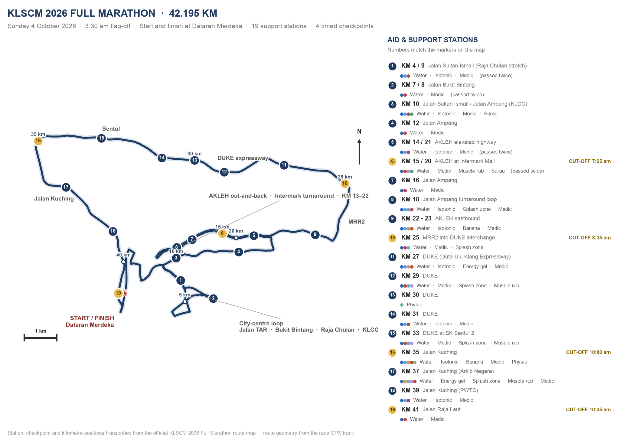
Switch between the street map and the schematic, filter by what you need (water, isotonic, gel, splash zone, surau…), then tap any station to see exactly what it carries and where it sits on the road.
| Segment | Where you are | What it feels like |
|---|---|---|
| KM 0–5 | Dataran Merdeka → Jalan Sultan Ismail → Jalan TAR → Dang Wangi → Jalan Ampang | Dark, cool, flat city blocks. Crowded for the first 2 km — let it flow, the first rise starts at KM 3.6. |
| KM 5–10 | Bukit Bintang loop, Pudu Sentral, Jalan Imbi, back onto Jalan Sultan Ismail | Tight turns and short ramps through the golden triangle, then the Raja Chulan pull from KM 8.6. |
| KM 10–13 | Past KLCC along Jalan Ampang to the AKLEH on-ramp | Fast and flat with wide lanes. The easiest place on the course to bank a little time. |
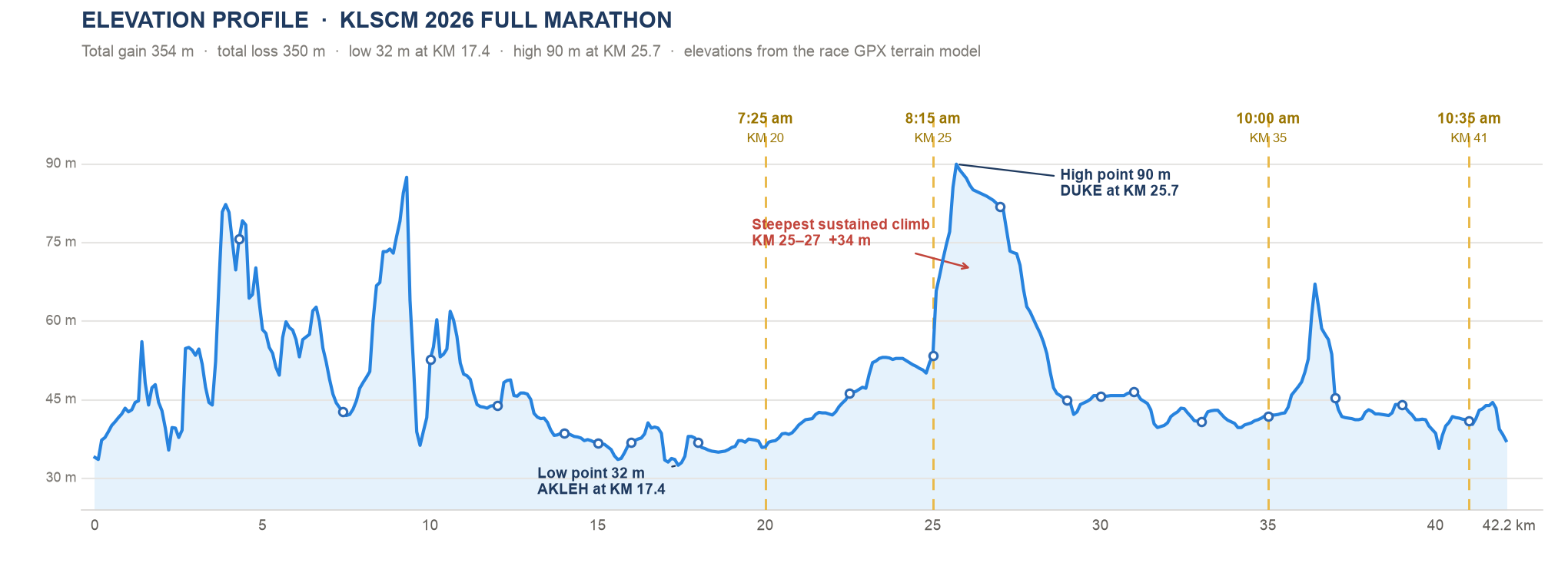
| KM 13–22 | AKLEH elevated highway, out-and-back with the turnaround loop at KM 17.1 | Exposed concrete, no shade, gentle grades. Course low point (32 m) at KM 17.2. Still dark until roughly KM 19. |
| KM 22–25 | AKLEH eastbound → Route 28 → MRR2 into the DUKE interchange | Long sweeping ramps. The KM 25 gate closes at 8:15 am — check the clock here. |
| KM 25–27 | DUKE expressway climb to the course high point | Hardest 2 km The one real climb: about +34 m to 92 m, with sunrise arriving at the same time. |
| KM 27–33 | Rolling DUKE viaducts through Sentul | A long, hot, shadeless stretch of rollers — but stations come every 1–2 km, including physio at KM 30. |
| KM 33–37 | Off DUKE at KM 34.9 onto Jalan Kuching (Route 1) | Wristband KM 35 gate at 10:00 am issues the wristband you need for your medal and finisher tee. |
| KM 37–42.2 | Jalan Kuching → PWTC → Jalan Raja Laut → Dataran Merdeka | Back on city streets, half marathoners merge around KM 40, then the finish in front of the Sultan Abdul Samad Building. |
20 cues from the GPX track — distances are GPX kilometres
| KM | Cue |
|---|---|
| 0.0 | Start on Jalan Raja at Dataran Merdeka, heading south |
| 1.4 | Right onto Jalan Sultan Ismail |
| 1.6 | Right onto Jalan Tuanku Abdul Rahman |
| 1.9 | Left onto Jalan Dang Wangi |
| 2.2 | Continue onto Jalan Munshi Abdullah |
| 2.7 | Onto Jalan Ampang, eastbound |
| 3.6 | Right onto Jalan Sultan Ismail — first climb of the day |
| 5.0 | Right onto Jalan Bukit Bintang |
| 5.4 | Past Pudu Sentral, onto Jalan Imbi |
| 6.2 | Left onto Jalan Sultan Ismail |
| 6.5 | Sharp right, then right again onto Jalan Bukit Bintang |
| 8.6 | Keep right onto Jalan Sultan Ismail — the Raja Chulan climb |
| 9.6 | Sharp right onto Jalan Ampang, past KLCC |
| 13.0 | Take the ramp onto E12 AKLEH |
| 17.1 | Turnaround loop — course low point just after |
| 22.9 | Follow Route 28 signs off AKLEH |
| 24.7 | Onto E33 DUKE — the main climb starts |
| 34.9 | Exit onto Route 1, Jalan Kuching |
| 39.0 | Past PWTC onto Jalan Raja Laut |
| 42.2 | Finish at Dataran Merdeka |
Elevation profile
Drag or hover across the profile to read the exact altitude, gradient and nearest station at any point. Station markers sit on the line; gold dashed lines are the timed gates.
Per-kilometre gain, loss and net change
Pace calculator
Pick a goal time and a pacing strategy. The calculator spreads your time over the real course — steeper kilometres get slower, the heat after sunrise gets a penalty — then checks every gate and tells you what time you will pass each station.
Halfway (21.1 km) at — · —
Your goal, strategy and wave are saved in this browser, so the station arrival times below stay in sync.
All 19 water & support stations
Transcribed from the official route map. Six stations are passed twice because of the Bukit Bintang loop and the AKLEH out-and-back, so you get 25 chances to drink across the course — but nothing at all in the first 4 km.
Arrival times follow the plan set in the pace calculator.
Cut-off gates
The full marathon has a seven hour limit, but the race is really decided at four intermediate gates. Miss one and you are pulled onto the sweeper bus, so these are the numbers to memorise.
| Gate | Clock time | Elapsed | Pace needed to here | What happens |
|---|---|---|---|---|
| KM 20 — AKLEH at Intermark | 7:25 am | 3:55 | 11:45 /km | First gate. Generous — if you are behind here, the day is already gone. |
| KM 25 — MRR2 into DUKE | 8:15 am | 4:45 | 11:24 /km | The gate sits at the foot of the climb, so arrive with margin, not on the line. |
| KM 35 — Jalan Kuching | 10:00 am | 6:30 | 11:08 /km | Wristband Collect the wristband here or you get no medal and no finisher tee. |
| KM 41 — Jalan Raja Laut | 10:35 am | 7:05 | 10:22 /km | Last gate, 1.2 km from home. |
| Finish — Dataran Merdeka | 10:30 am | 7:00 | 9:57 /km | The official full marathon cut-off is seven hours from your wave flag-off. |
The 35 → 41 squeeze. The published gates allow 11:45/km to KM 20, then 10:00/km, then 10:30/km — but only about 5:50/km between KM 35 and KM 41. Anyone near the back must arrive at KM 35 well before 10:00 am, because that final segment is far tighter than the average suggests.
Wristbands at KM 35. Marshals hand out wristbands at the KM 35 gate. No wristband means no finisher medal or tee even if you cross the line, so do not run past the marshal.
Race day playbook
What the course does to you, in order — and how to spend your energy so the DUKE climb and the post-sunrise heat do not end your race.
1. KM 0–13 · keep it boring
Cool, dark, flat. Run 10–15 seconds per km slower than goal pace through the crowded start, drink at KM 4 even if you do not feel thirsty, and treat the Raja Chulan rise at KM 8.6 as a stroll.
2. KM 13–25 · bank a little
The AKLEH out-and-back is the flattest, fastest stretch. Settle into goal pace, take isotonic at KM 14 and KM 22, and aim to reach the KM 25 gate 20–30 minutes before 8:15 am.
3. KM 25–27 · climb small
Shorten your stride for about +34 m of climb to the high point. Losing 30–45 seconds here is normal; blowing up here costs 15 minutes later.
4. KM 27–33 · sun and rollers
Sunrise lands on the shadeless DUKE viaducts. Take water and a splash at every station, use the KM 30 physio stop if a niggle appears, and let the rollers dictate effort, not pace.
5. KM 33–37 · get the wristband
Off the highway onto Jalan Kuching. Collect the KM 35 wristband, take the banana and gel on offer, then start counting down — only a 10 km parkrun-and-a-bit remains.
6. KM 37–42.2 · finish honest
27–30 °C and humid by now. Water at KM 37, 39 and 41, ignore the half marathoners merging near KM 40, and drive to the line in front of the Sultan Abdul Samad Building.
Hydration maths. There is nothing before KM 4 and nothing between KM 41 and the finish, but stations sit every 1–2 km from KM 25 onwards. In KL humidity plan on 400–600 ml per hour: water at every table after KM 25, isotonic at the nine stations that carry it, and use the splash zones on your head and wrists, not your stomach.
Race weekend. Saturday 3 October: IHH Healthcare 10 km at 6:00 am, 5 km at 7:45 am, Kids Dash at 10:00 am, 2 km at 10:20 am. Sunday 4 October: full marathon at 3:30 am with announcements from about 3:15 am, half marathon at 4:45 am. The half marathon cut-off is 3:30 hours.
Downloads
Everything in this guide is derived from the official KLSCM 2026 route map and the published GPX track.
Accuracy notes. The GPX track measures 42.512 km against the certified 42.195 km, so it runs about 0.75% long — all pace maths on this site uses the official distance. Altitudes come from the track’s elevation data and are good for shape and gradient, not survey-grade heights. Cut-off times, station positions and facilities are transcribed from the official 2026 route map; always confirm against the organiser before race day.